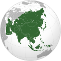
Afaylu:Asia (orthographic projection).svg

Afaylu anṣli (Afaylu SVG, tabadut n 541 × 541 id piksil, tiddi n ufaylu: 557 kio)
Afaylu ad ikka d Wikimedia Commons, iẓḍar ad ittusmras ɣ isntay yaḍnin. Aglam illan ɣ tasna nns n uglam illa ddaw as.
Azgzl
| AglamAsia (orthographic projection).svg |
العربية: الخريطة الهجائية لآسيا English: Asia |
||||
| Asakud | |||||
| Asagm |
National Geographic. Map by Ssolbergj
|
||||
| Amgay | Koyos + Ssolbergj | ||||
| Autres versions |
العربية: الرجاء، قراءة الميثاق.
বাংলা: দয়া করে, রীতিনীতিটি পড়ুন।
Deutsch: Bitte lies die Konventionen.
English: Please, read the conventions.
Español: Por favor, lea las convenciones.
Filipino: Paki-basa ang mga kumbensyon.
Français : S'il vous plaît, lisez les conventions.
हिन्दी: कृपया सभागमों को पढ़ लें.
Bahasa Indonesia: Silakan, baca konvensi.
Italiano: Si prega di leggere le convenzioni.
日本語: 規約をご確認ください。
ქართული: გთხოვთ, გაეცნოთ კონვენციებს.
Македонски: Ве молиме, прочитајте ги општоприфатените правила.
Português: Por favor, leia as convenções.
Русский: Пожалуйста, прочитайте соглашения.
Tagalog: Paki-basa ang mga kumbensyon.
Українська: Будь ласка, прочитайте конвенції.
Tiếng Việt: Hãy đọc công văn trước khi đăng.
|
||||
| SVG information InfoField |
Taragt

|
Dark turagt n ad tssnɣlt, ad tbḍut d ad tsnflt tantamt ad ddu tfadiwin n turagt jinu i tntamin tilelliyin tunɣilt 1.2 nɣ tunɣilt tamaynut akk nna tẓrg tamrslt n isuftwurn ilelliyn, min tizuniwin armskiln, min aḍris n tasna tamzwarut n tduli d min aḍris n tasna tamggarut n tduli.Yat tunɣilt n turagt tkcm ɣ tzuni ilan azwl GNU Free Documentation License.http://www.gnu.org/copyleft/fdl.htmlGFDLGNU Free Documentation Licensetruetrue |
- Tgit win ixf nnk/nnm:
- fsr – afad ad tnɣlt, ad tzuzrt nɣ ad tbḍut tawuri ad
- sgiddi – sgiddi tawuri
- Ddu tfadiwin ad:
- Tibbabwt – Iqqan d ad tbdrm ism n umskar anṣli tbdrm ula asɣun immaln amskar n umahil nɣ bab n izrfan, tbdrm iɣ ittwasnfl zgis kra nɣ d uhu. Tzḍarm ad tskrm mk ad s mk da tram, maccan s kra n tɣarast immaln ma s d imsacka bab n twuri.
- fsr ikniwn – Iɣ tsnflm nɣ tsmattim nɣ tẓkim f twuri ad, illa fllawn ad tbḍum tumutin nnun ddu turaqt ann nit nɣ kra n turagt d yuckan d tdslant.
| Annotations InfoField | Cette image est annotée : Voir les annotations sur Wikimedia Commons |
India
Sri Lanka
Russia
Mongolia
China
Africa
Oceania
South Korea
North America
Europe
North Korea
Japan
Pakistan
Saudi Arabia
Kazakhstan
Papua New Guinea
Indonesia
Nepal
Iran
Cyprus
Kamchatka
Hokkaido
Cambodia
Turkey
Afghanistan
Bhutan
Philippines
Malaysia
Thailand
Vietnam
Légendes
statut des droits d'auteur ⵜⴰⴼⵔⴰⵏⵙⵉⵙⵜ
sous droit d'auteur ⵜⴰⴼⵔⴰⵏⵙⵉⵙⵜ
licence ⵜⴰⴼⵔⴰⵏⵙⵉⵙⵜ
Licence de documentation libre GNU ⵜⴰⴼⵔⴰⵏⵙⵉⵙⵜ
date de fondation ou de création ⵜⴰⴼⵔⴰⵏⵙⵉⵙⵜ
15 Mars 2009
type MIME ⵜⴰⴼⵔⴰⵏⵙⵉⵙⵜ
image/svg+xml
somme de contrôle ⵜⴰⴼⵔⴰⵏⵙⵉⵙⵜ
172f5e66318d09590c698956d4edb40320c8ce53
taille des données ⵜⴰⴼⵔⴰⵏⵙⵉⵙⵜ
570 850 octet
hauteur ⵜⴰⴼⵔⴰⵏⵙⵉⵙⵜ
541 pixel
largeur ⵜⴰⴼⵔⴰⵏⵙⵉⵙⵜ
541 pixel
Amzruy n ufaylu
Adr i usakud/akud ad tẓrt afaylu mk lli tt inn ikka ɣ tizi ann.
| Asakud/Akud | Tawlaft mẓẓin | Imnadn | Asmras | Axfawal | |
|---|---|---|---|---|---|
| amiran | 29 Yulyu 2023 à 19:11 |  | 541 × 541 (557 kio) | Bennylin | synchronize with File:Southeast Asia (orthographic projection).svg. Source: File:United Nations geographical subregions.png |
| 18 Mars 2023 à 01:57 |  | 541 × 541 (496 kio) | Golden Mage | A change to the map of Asia will first face debate from others. Hence, a change to the commonly accepted map of Oceania cannot be made without a wider consensus. | |
| 17 Mars 2023 à 04:44 |  | 541 × 541 (557 kio) | Kwamikagami | the Weber line divides Asian from Oceanic Wallacea | |
| 4 Cutambir 2022 à 20:29 |  | 541 × 541 (496 kio) | Рагин1987 | Socotra repainted | |
| 4 Cutambir 2022 à 18:20 |  | 541 × 541 (492 kio) | Рагин1987 | Final edit | |
| 4 Cutambir 2022 à 13:43 |  | 541 × 541 (446 kio) | Рагин1987 | Correction | |
| 31 Ɣuct 2022 à 14:13 |  | 2 048 × 2 048 (1,04 Mio) | Рагин1987 | Small correction (Socotra Island is geologically closer to Africa) | |
| 13 Dujanbir 2019 à 18:59 |  | 541 × 541 (242 kio) | Goran tek-en | Added border for South Sudan as requested by {{u|Maphobbyist}} | |
| 13 Bṛayṛ 2019 à 11:16 |  | 541 × 541 (161 kio) | عبد الله | Reverted to version as of 16:47, 19 September 2016 (UTC) | |
| 13 Bṛayṛ 2019 à 11:11 |  | 512 × 512 (120 kio) | عبد الله | إزاة خطوط زعجة |
Asmrs n ufaylu
9 tasniwin ad iḍfarn gisnt afaylu ad:
Aswuri aɣzuran n ufaylu
Id wiki ad ar swurin s ufaylu ad:
- Asmrs ɣ ab.wikipedia.org
- Asmrs ɣ ace.wikipedia.org
- Asmrs ɣ ady.wikipedia.org
- Asmrs ɣ af.wikipedia.org
- Afrika
- Asië
- Europa
- Filippyne
- Irak
- Israel
- Japan
- Noord-Amerika
- Suid-Amerika
- Volksrepubliek China
- Thailand
- Singapoer
- Maleisië
- Afghanistan
- Sjabloon:Kontinente
- Bangkok
- Katar
- Taipei
- Indië
- Rusland
- Oesbekistan
- Hoofstad
- Lys van hoofstede
- Siprus
- Armenië
- Sjabloon:Lande van Asië
- Iran
- Egipte
- Wikipedia:Sjabloon
- Turkmenistan
- Wikipedia:Lys van sjablone
- Britse Indiese Oseaangebied
- Suid-Korea
- Noord-Korea
- Antarktika
- Beijing
- Gondwana
- Eurasië
- Laurasië
- Kategorie:Lande in Asië
- Libanon
- Jerusalem
- Azerbeidjan
- Bahrein
Ẓruggar f ussmrs amatay n ufaylu ad.
Metadata
Yuma ufaylu ad umlan yaḍnin, lli d tfl takamirat tuṭunit nɣ d aṣfḍ ittusmrasn i usnflul nns.
Iɣ ibadl afaylu zɣ addad nns amzwaru, kra n ifruritn, ur ɣint ad gint d timkdant s ufaylu amiran.
| Largeur | 541.48 |
|---|---|
| Hauteur | 541.48 |


