Afaylu:Mediterranean Sea political map-es.svg
Aller à la navigation
Aller à la recherche

Taille de cet aperçu PNG pour ce fichier SVG : 800×585 piksil. Tibuda yaḍnin:320×234 piksil | 640×468 piksil | 1 024×749 piksil | 1 280×936 piksil | 2 560×1 872 piksil | 2 046×1 496 piksil
Afaylu anṣli (Afaylu SVG, tabadut n 2 046 × 1 496 id piksil, tiddi n ufaylu: 1,1 Mio)
| Aglam |
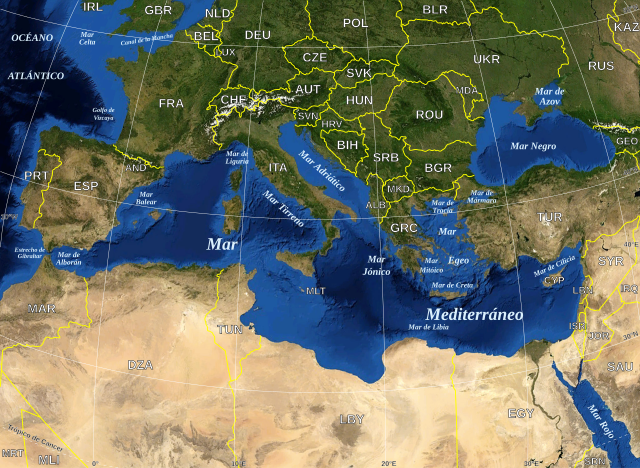
English: Map in Spanish of the Mediterranean Sea, with the borders and the name of the States following the ISO 3166-1 Alpha-3 code. Español: Mapa en español del Mar Mediterraneo con las fronteras y los nombres de los estados siguiendo el código ISO 3166-1 Alpha-3. |
| Asakud | (UTC) |
| Asagm | |
| Amgay |
|
| Cette image a été retouchée, ce qui signifie qu'elle a été modifiée par ordinateur et est différente de l'image d'origine. Liste des modifications : Versión en español. L'image d'origine se trouve ici : Mediterranean Sea political map-en.svg:
|
| Cette image est dans le domaine public car elle est constituée d'une capture d'écran du logiciel World Wind de la NASA qui utilise des données du domaine public, comme Blue Marble, MODIS, Landsat, SRTM, USGS ou GLOBE.
|
 |
| This work was previously under Public Domain, or a Free License. It has been digitally enhanced and/or modified. This derivative work has been (or is hereby) released into the public domain by its author, [[:{{{1}}}:User:{{{3}}}|{{{3}}}]] at the [[:{{{1}}}:|{{{2}}}]] project. This applies worldwide. In some countries this is not legally possible; if so:
|
Journal des téléversements d’origine
This image is a derivative work of the following images:
- File:Mediterranean_Sea_political_map-en.svg licensed with PD-WorldWind, PD-retouched-user-w
- 2008-05-19T16:18:12Z Sting 2046x1496 (1148854 Bytes) "Tropic of Cancer" label correction
- 2007-06-21T01:01:36Z Sting 2046x1496 (1148419 Bytes) {{Information |Description=Map in English of the [[:en:Mediterranean Sea|Mediterranean Sea]], with the borders and the name of the States following the ISO 3166-1 Alpha-3 code. |Source=Own work ;Background map : screenshot fr
Téléversé avec derivativeFX
Amzruy n ufaylu
Adr i usakud/akud ad tẓrt afaylu mk lli tt inn ikka ɣ tizi ann.
| Asakud/Akud | Tawlaft mẓẓin | Imnadn | Asmras | Axfawal | |
|---|---|---|---|---|---|
| amiran | 13 Yunyu 2010 à 19:32 | | 2 046 × 1 496 (1,1 Mio) | Edoarado | Corregido error en "Océano Atlántico", el texto aparecía del revés. |
| 13 Yunyu 2010 à 19:16 |  | 2 046 × 1 496 (1,1 Mio) | Edoarado | {{Information |Description={{en|Map in Spanish of the Mediterranean Sea, with the borders and the name of the States following the ISO 3166-1 Alpha-3 code.}} {{es|Mapa en español del Mar Mediterraneo con |
Asmrs n ufaylu
tasna ad iḍfarn gis afaylu ad:
Aswuri aɣzuran n ufaylu
Id wiki ad ar swurin s ufaylu ad:
- Asmrs ɣ ar.wikipedia.org
- Asmrs ɣ arz.wikipedia.org
- Asmrs ɣ ast.wikipedia.org
- Asmrs ɣ ca.wikipedia.org
- Asmrs ɣ el.wikipedia.org
- Asmrs ɣ en.wikipedia.org
- Asmrs ɣ es.wikipedia.org
- Asmrs ɣ eu.wikipedia.org
- Asmrs ɣ fi.wiktionary.org
- Asmrs ɣ fr.wikinews.org
- Asmrs ɣ ga.wikipedia.org
- Asmrs ɣ gl.wikipedia.org
- Asmrs ɣ ha.wikipedia.org
- Asmrs ɣ ia.wikipedia.org
- Asmrs ɣ kab.wikipedia.org
- Asmrs ɣ la.wikipedia.org
- Asmrs ɣ mzn.wikipedia.org
- Asmrs ɣ pnb.wikipedia.org
- Asmrs ɣ pt.wikipedia.org
- Asmrs ɣ vec.wikipedia.org
- Asmrs ɣ www.wikidata.org