Afaylu:Abbasid Caliphate 850AD.png
Aller à la navigation
Aller à la recherche
Aksay n uẓṛi ad :800×497 piksil Tibuda yaḍnin:320×199 piksil | 640×398 piksil | 1 024×637 piksil | 1 280×796 piksil | 2 163×1 345 piksil
Afaylu anṣli (2 163 × 1 345 piksil, tiddi n ufaylu: 798 kio, anaw MIME: image/png)
Azgzl
| Aglam |
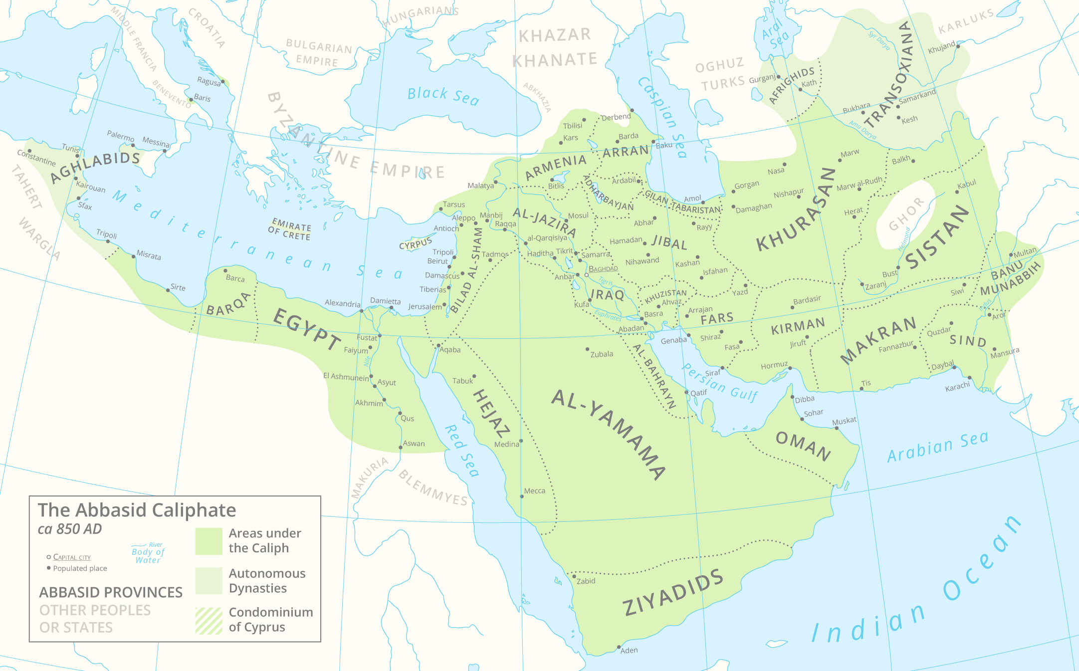
English: A map of the Abbasid Caliphate around 850 AD featuring provinces and settlements. |
| Asakud | |
| Asagm |
Tawuri inu.
Cette PNG image matricielle a été créée avec Adobe Illustrator. |
| Amgay | Cattette |
| Autres versions | العربيَّة |
Taragt
Moi, en tant que détenteur des droits d’auteur sur cette œuvre, je la publie sous la licence suivante :
Ce fichier est disponible selon les termes de la licence Creative Commons Attribution 4.0 International.
- Tgit win ixf nnk/nnm:
- fsr – afad ad tnɣlt, ad tzuzrt nɣ ad tbḍut tawuri ad
- sgiddi – sgiddi tawuri
- Ddu tfadiwin ad:
- Tibbabwt – Iqqan d ad tbdrm ism n umskar anṣli tbdrm ula asɣun immaln amskar n umahil nɣ bab n izrfan, tbdrm iɣ ittwasnfl zgis kra nɣ d uhu. Tzḍarm ad tskrm mk ad s mk da tram, maccan s kra n tɣarast immaln ma s d imsacka bab n twuri.
Amzruy n ufaylu
Adr i usakud/akud ad tẓrt afaylu mk lli tt inn ikka ɣ tizi ann.
| Asakud/Akud | Tawlaft mẓẓin | Imnadn | Asmras | Axfawal | |
|---|---|---|---|---|---|
| amiran | 29 Mars 2021 à 14:05 | | 2 163 × 1 345 (798 kio) | Cattette | Tweaked provinces, added Arabia |
| 17 Mars 2021 à 09:13 |  | 2 163 × 1 052 (691 kio) | Cattette | Tweaked provinces | |
| 16 Mars 2021 à 13:05 |  | 2 163 × 1 052 (690 kio) | Cattette | More provinces | |
| 15 Mars 2021 à 07:10 |  | 2 163 × 1 052 (666 kio) | Cattette | Added more cities, removed the Canal of the Pharaohs, added more divisions | |
| 10 Mars 2021 à 22:48 |  | 2 105 × 1 052 (508 kio) | Cattette | Uploaded own work with UploadWizard |
Asmrs n ufaylu
tasna ad iḍfarn gis afaylu ad:
Aswuri aɣzuran n ufaylu
Id wiki ad ar swurin s ufaylu ad:
- Asmrs ɣ ar.wikipedia.org
- Asmrs ɣ ast.wikipedia.org
- Asmrs ɣ az.wikipedia.org
- Asmrs ɣ bn.wikipedia.org
- Asmrs ɣ ca.wikipedia.org
- Asmrs ɣ cs.wikipedia.org
- Asmrs ɣ de.wikipedia.org
- Asmrs ɣ diq.wikipedia.org
- Asmrs ɣ el.wikipedia.org
- Asmrs ɣ en.wikipedia.org
- Asmrs ɣ es.wikipedia.org
- Asmrs ɣ eu.wikipedia.org
- Asmrs ɣ fa.wikipedia.org
- Asmrs ɣ fi.wikipedia.org
- Asmrs ɣ ga.wikipedia.org
- Asmrs ɣ gl.wikipedia.org
- Asmrs ɣ ha.wikipedia.org
- Asmrs ɣ ia.wikipedia.org
- Asmrs ɣ ko.wikipedia.org
- Asmrs ɣ lt.wikipedia.org
- Asmrs ɣ lv.wikipedia.org
- Asmrs ɣ mg.wikipedia.org
- Asmrs ɣ mn.wikipedia.org
- Asmrs ɣ ms.wikipedia.org
- Asmrs ɣ pnb.wikipedia.org
- Asmrs ɣ pt.wikipedia.org
- Asmrs ɣ ro.wikipedia.org
- Asmrs ɣ sq.wikipedia.org
- Asmrs ɣ ta.wikipedia.org
- Asmrs ɣ th.wikipedia.org
- Asmrs ɣ tr.wikipedia.org
- Asmrs ɣ uk.wikipedia.org
- Asmrs ɣ ur.wikipedia.org
Ẓruggar f ussmrs amatay n ufaylu ad.